
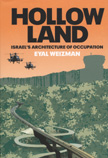
 …view: Hollow Land. The Architecture of Occupation: An exploration of the political space created by Israel’s colonial occupation. From the deep subterranean spaces of the West Bank and Gaza to their militarized airspace, the mechanisms of control and the transformation of the Occupied Territories into a theoretically constructed artifice is shown, in which natural and built features function as the weapons and ammunition with which the conflict is waged. Und bei aller Perspektivenkritik nicht ganz ohne Relevanz: Kartenmaterial. Ein kleiner Video-Clip mit moderierten Landkarten bietet einen recht vernünftig geratenen Einstieg/Überblick über die Problematik Mauer/Grüne Linie, aus der arte-Reihe „Mit offenen Karten“.
Schlagwort: kritische-Kartographie
Über Militärischen Urbanismus…

…mehr als nur ein Blog!
Parcour…
…eine Fortbewegungsart, bei der andere Wege genommen werden als die, die auf architektonische und sonstige Art und Weise vorgegeben sind (vgl. Wikipedia: Parcour). Für die Beweglicheren unter uns spätestens seit dem Film „Banlieue 13“ (2004, dt: „Ghettogangz“) der letzte Schrei. Aber so neu auch wieder nicht, wie historisches Filmmaterial zeigt: Parcourszenen aus den 20ern. Für die Couch-Parcourler gibts tonnenweise mehr coole Parcour-Clips bei YouTube…
Terrormap
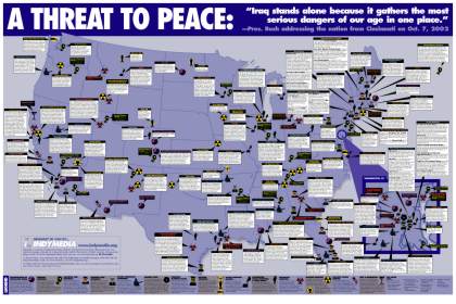 Bei indymedia New York gibts die „Terrormap“: Eine kartographische Darstellung der Orte des militärisch-strategisch-politisch-industriellen Komplexes in den USA. Terrormap zum Download (pdf, ca. 450 kb) und zum Bestellen per Post.
Die Realisierung eines entsprechenden Überblicks über die Militarisierung Deutschlands/Europas gibt es noch nicht. Anlass und Material dazu gibts aber allemal.